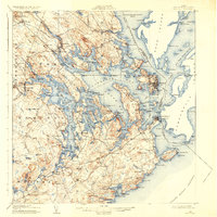
1908 Map of Eastport
USGS Topo · Published 1935About this map
Eastport and the surrounding islands of Passamaquoddy Bay anchor this maritime landscape at a time when water and rail were the primary engines of the local economy. The Washington County Railway cuts across the mainland, serving inland junctions like Ayers Junction and coastal stations such as Dennysville Station. Along the intricate shoreline of Cobscook Bay, a network of landings and ferries, including the North Lubec Landing, facilitated trade and movement before modern road connectivity. Small rural communities are documented through their essential institutions, including the Crowe Neck School, Wilcox School, and the Crosby School in Whiting. The international border with Canada is clearly delineated, passing through the waters of the Friar Roads and past the settlement of Welshpool on Campobello Island. This survey details the transition from high points like Mt Dorcas to the numerous coves and islands that define this corner of Washington County.
Find a feature on this map
214 named features on this map. Tap any name to fly to it.
Don’t see what you’re looking for? This feature index may not catch every label — zoom into the map to look around manually.
Map Details
Editions of this 1908 Eastport Map
4 editions found
Other maps of this area

1907 · Eastport
USGS Topo · 1:48,000

1908 · Eastport
USGS Topo · 1:62,500

1917 · Cutler
USGS Topo · 1:62,500

1918 · Machias
USGS Topo · 1:62,500

1918 · Cutler
USGS Topo · 1:62,500

1929 · Calais
USGS Topo · 1:48,000

1929 · Robbinston
USGS Topo · 1:48,000

1931 · Robbinston
USGS Topo · 1:62,500

1932 · Calais
USGS Topo · 1:62,500

1941 · Machias
USGS Topo · 1:62,500