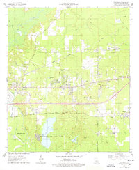
1975 Map of Eastwood
USGS Topo · Published 1978About this map
Barksdale Air Force Base dominates the southern landscape of this Bossier Parish survey, showing the extensive Sligo gas and oil field operations and the waters of Flag Lake. To the north, the corridor along the Kansas City Southern railroad line and the Illinois Central Gulf tracks anchors the residential and commercial growth of Eastwood and Haughton. This era captures the region's mid-1970s development, where suburban expansion like the Eastwood Fairways Country Club sits adjacent to traditional rural landmarks such as Pease Chapel, Sunlight Ch, and Zion Hill Ch. The mapping of local infrastructure is dense, including the Platt Sch, numerous radio towers, and the sprawling Hillcrest Memorial Park Cem near Red Chute. Drainage patterns are defined by the winding paths of Fifi Bayou and Musselshell Bayou as they move through the lowlands east of Bossier City.
Find a feature on this map
59 named features on this map. Tap any name to fly to it.
Don’t see what you’re looking for? This feature index may not catch every label — zoom into the map to look around manually.
Map Details
Editions of this 1975 Eastwood Map
This is the sole edition of this map. No revisions or reprints were ever made.
Other maps of this area

1932 · Bossier SE
USGS Topo · 1:31,680

1932 · Bossier NE
USGS Topo · 1:31,680

1932 · Bossier SW
USGS Topo · 1:31,680

1932 · Bossier NW
USGS Topo · 1:31,680

1938 · Arnsberg
USGS Topo · 1:31,680

1941 · Forbing
USGS Topo · 1:31,680

1947 · Ringgold
USGS Topo · 1:62,500

1947 · Minden
USGS Topo · 1:62,500

1948 · Bossier City
USGS Topo · 1:62,500

1948 · Caspiana
USGS Topo · 1:62,500