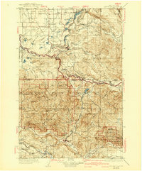
1937 Map of Eatonville
USGS Topo · Published 1942About this map
Eatonville serves as the central hub of this 1930s landscape, where timber extraction and mountain topography dictate the placement of settlements and infrastructure. The Mashel River and Nisqually River carve through the terrain, providing the corridor for the Chicago Milwaukee St Paul and Pacific RR and several specialized logging lines, such as the St Paul and Tacoma Lumber RR and the Eatonville Lumber RR. These railroads represent a peak era of industrial forestry before the widespread adoption of heavy trucking in the Cascade foothills.
Find a feature on this map
126 named features on this map. Tap any name to fly to it.
Don’t see what you’re looking for? This feature index may not catch every label — zoom into the map to look around manually.
Map Details
Editions of this 1937 Eatonville Map
3 editions found
Other maps of this area

1897 · Tacoma
USGS Topo · 1:125,000

1900 · Tacoma
USGS Topo · 1:125,000

1913 · Cedar Lake
USGS Topo · 1:125,000

1916 · Chehalis
USGS Topo · 1:125,000

1919 · Mount St Helens
USGS Topo · 1:125,000

1924 · Mt Rainier
USGS Topo · 1:96,000

1926 · Steamboat Mtn
USGS Topo · 1:125,000

1928 · Mt Rainier
USGS Topo · 1:125,000
1931 · Steamboat Mtn
USGS Topo · 1:125,000

1937 · Eatonville
USGS Topo · 1:125,000