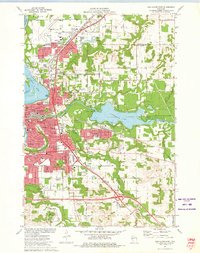
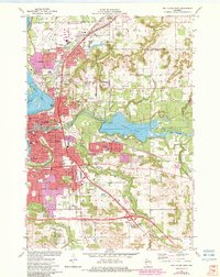
1972 Map of Eau Claire East
USGS Topo · Published 1975About this map
Lake Altoona and the winding Chippewa River anchor this mid-1970s survey of the growing metropolitan region. The map documents a significant era of suburban expansion and educational development, featuring the University of Wisconsin Eau Claire campus and numerous parochial and public schools like Regis High Sch and St Olaf Sch. Infrastructure is prominent, with the Eau Claire Municipal Airport in the north and the Chicago and North Western rail lines cutting through the landscape.
Find a feature on this map
51 named features on this map. Tap any name to fly to it.
Don’t see what you’re looking for? This feature index may not catch every label — zoom into the map to look around manually.
Map Details
Editions of this 1972 Eau Claire East Map
2 editions found
Other maps of this area

1927 · Strum
USGS Topo · 1:62,500

1930 · Strum
USGS Topo · 1:62,500

1932 · Mondovi
USGS Topo · 1:62,500

1934 · Elk Mound
USGS Topo · 1:62,500

1934 · Chippewa Falls
USGS Topo · 1:62,500

1936 · Chippewa Falls
USGS Topo · 1:62,500

1936 · Elk Mound
USGS Topo · 1:62,500

1953 · Eau Claire
USGS Topo · 1:250,000

1958 · Eau Claire
USGS Topo · 1:250,000

1964 · Eau Claire
USGS Topo · 1:250,000