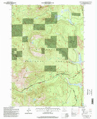
1994 Map of Echo Mountain
USGS Topo · Published 1998About this map
The Santiam Wagon Road cuts through the high Cascades on this survey, tracing a historic transportation corridor through the Willamette National Forest. The landscape is dominated by a complex network of volcanic and aquatic features, including the stark contrast between Lava Lake and the nearby Hackleman Old-Growth Grove. Significant elevation changes are marked by peaks such as Echo Mountain and the prominent Browder Ridge, which overlooks the Smith River drainage.
Find a feature on this map
40 named features on this map. Tap any name to fly to it.
Don’t see what you’re looking for? This feature index may not catch every label — zoom into the map to look around manually.
Map Details
Editions of this 1994 Echo Mountain Map
This is the sole edition of this map. No revisions or reprints were ever made.
Other maps of this area

1927 · Mt. Jefferson
USGS Topo · 1:125,000

1929 · Mill City
USGS Topo · 1:125,000

1929 · Three Sisters
USGS Topo · 1:125,000

1930 · Mt. Jefferson
USGS Topo · 1:125,000

1932 · Three Sisters
USGS Topo · 1:125,000

1934 · Mc Kenzie Bridge
USGS Topo · 1:96,000

1940 · Mc Kenzie Bridge
USGS Topo · 1:125,000

1953 · Salem
USGS Topo · 1:250,000

1954 · Salem
USGS Topo · 1:250,000

1955 · Echo Mountain
USGS Topo · 1:62,500