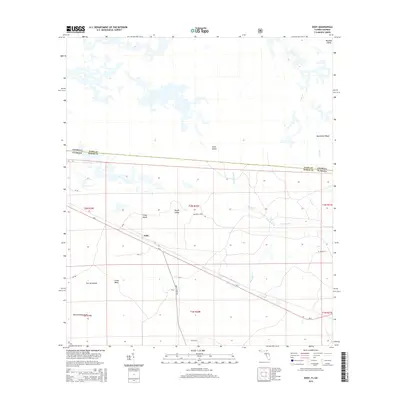
2015 Map of Eddy
USGS Topo · Published 2015About this map
Eddy sits at the intersection of SR-2 and Eddy Grade Rd in the marshy borderlands of Baker County. This landscape is defined by its complex hydrography, where the waters of Moccasin Cr and Lake Holes Br thread through a series of islands and ridges that rise just above the wetlands. Named terrain features like Rough Island, Crews Island, and Mitchell Island indicate a history of land use and navigation within this swampy environment, while Moonshine Ridge hints at the local character of the terrain east of Lake Holes. The map clearly delineates the Georgia-Florida state line, cutting across these wild spaces. For researchers, the presence of family-named roads like El Crews Ln and established forestry routes like NF-20 provides a clear view of the transportation network supporting the area's rural residents and timber interests during the early 21st century.
Find a feature on this map
32 named features on this map. Tap any name to fly to it.
Don’t see what you’re looking for? This feature index may not catch every label — zoom into the map to look around manually.
Map Details
Editions of this 2015 Eddy Map
This is the sole edition of this map. No revisions or reprints were ever made.
Other maps of this area
1917 · Macclenny
USGS Topo · 1:62,500
1918 · Moniac
USGS Topo · 1:62,500
1918 · Macclenny
USGS Topo · 1:62,500
1942 · Moniac
USGS Topo · 1:62,500

1954 · Valdosta
USGS Topo · 1:250,000
1956 · Eddy
USGS Topo · 1:24,000
1956 · Sargent
USGS Topo · 1:24,000
1958 · Valdosta
USGS Topo · 1:250,000
1959 · Valdosta
USGS Topo · 1:250,000
1965 · Chesser Island
USGS Topo · 1:24,000