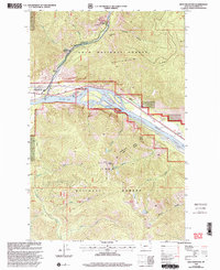
1999 Map of Eddy Mountain
USGS Topo · Published 2003About this map
Eddy Mountain and the surrounding high-elevation terrain of the Lolo National Forest dominate this landscape, where mining operations and river systems intersect in Sanders County. The northern sector highlights a concentrated legacy of mineral extraction with the Raven Mine, Copper King Mine, and Silver King Mine situated near the Thompson River. This confluence of topography and resource development is further anchored by the Clark Fork, which carves through the center of the sheet, flanked by the Montana FWP Wildlife Mgmt Area and a dedicated Sheep Viewing Site. Small settlements like Snider and Eddy provide evidence of early infrastructure alongside the Gaging Station, while the ridgelines of Koo Koo-Sint Ridge define the vertical relief of the territory. The map serves as a detailed record of land management, showing the boundaries of the Thompson Falls Plains Ranger District amidst a network of mountain creeks and alpine lakes.
Find a feature on this map
34 named features on this map. Tap any name to fly to it.
Don’t see what you’re looking for? This feature index may not catch every label — zoom into the map to look around manually.
Map Details
Editions of this 1999 Eddy Mountain Map
This is the sole edition of this map. No revisions or reprints were ever made.
Other maps of this area

1918 · St Regis
USGS Topo · 1:125,000

1919 · St. Regis
USGS Topo · 1:125,000

1937 · Thompson Falls
USGS Topo · 1:125,000

1937 · Thompson Falls
USGS Topo · 1:62,500

1956 · St Regis
USGS Topo · 1:62,500

1956 · Wallace
USGS Topo · 1:250,000

1957 · Thompson Falls
USGS Topo · 1:62,500

1957 · Haugan
USGS Topo · 1:62,500

1960 · Wallace
USGS Topo · 1:250,000

1964 · Calico Creek
USGS Topo · 1:24,000