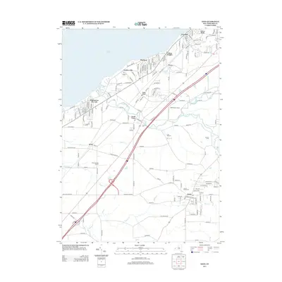
2013 Map of Eden
USGS Topo · Published 2013About this map
The town of Eden and its surrounding agricultural and coastal neighborhoods are captured here along the eastern shores of Lake Erie. The landscape is defined by the deep incisions of Eighteenmile Cr and its tributaries, including South Br Eighteen mile Cr and Pike Cr, which flow toward the lake. This 2013 survey illustrates a mix of traditional farmsteads, such as Triple Oak Farms and Preischel Farms, alongside expanding lakeside residential clusters like Wanakah and Clifton Heights. Aviation history is visible through the presence of both the Hamburg Inc Airport and the Evans Airways Airport, serving the region's transport needs. Genealogists may find interest in the documented sites of N Evans Cem and Evergreen Cem, which remain as anchor points for the area's local history.
Find a feature on this map
155 named features on this map. Tap any name to fly to it.
Don’t see what you’re looking for? This feature index may not catch every label — zoom into the map to look around manually.
Map Details
Editions of this 2013 Eden Map
This is the sole edition of this map. No revisions or reprints were ever made.
Other maps of this area

1894 · Buffalo
USGS Topo · 1:62,500

1899 · Silver Creek
USGS Topo · 1:62,500

1901 · Buffalo
USGS Topo · 1:62,500

1905 · Eden
USGS Topo · 1:62,500

1907 · Eden
USGS Topo · 1:62,500

1944 · Eden
USGS Topo · 1:62,500

1944 · North Collins
USGS Topo · 1:31,680

1944 · Hamburg
USGS Topo · 1:31,680
1944 · Angola
USGS Topo · 1:31,680

1944 · Farnham
USGS Topo · 1:31,680