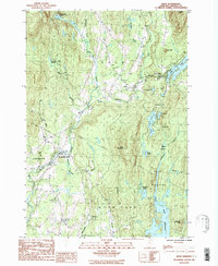
1986 Map of Eden
USGS Topo · Published 1986About this map
The Gihon River and its numerous tributaries carve through the townships of Eden, Johnson, and Hyde Park, creating a landscape defined by high ridges and secluded valley settlements. In the mid-1980s, the village of Eden Mills and the town of Eden served as focal points for local commerce, while the northern reaches were dominated by water bodies like Eden Lake and the remote Ritterbush Pond. The terrain is characterized by named elevations such as Bean Mountain and The Knob, with the Green River Reservoir forming a significant feature in the southeastern corner. Historical land use is evident in the presence of scattered Cem locations and localized industrial sites like the Gravel Pit near the riverbanks. This era shows the established road networks connecting North Hyde Park and Centerville, illustrating how the mountainous topography dictated the development of these Vermont communities.
Find a feature on this map
39 named features on this map. Tap any name to fly to it.
Don’t see what you’re looking for? This feature index may not catch every label — zoom into the map to look around manually.
Map Details
Editions of this 1986 Eden Map
This is the sole edition of this map. No revisions or reprints were ever made.
Other maps of this area

1919 · Montgomery
USGS Topo · 1:62,500

1920 · Montgomery
USGS Topo · 1:62,500

1920 · Irasburg
USGS Topo · 1:62,500

1923 · Irasburg
USGS Topo · 1:48,000

1925 · Irasburg
USGS Topo · 1:62,500

1925 · Jay Peak
USGS Topo · 1:62,500

1927 · Hyde Park
USGS Topo · 1:48,000

1928 · Hardwick
USGS Topo · 1:62,500

1930 · Hyde Park
USGS Topo · 1:62,500

1934 · Hardwick
USGS Topo · 1:48,000