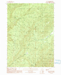
1990 Map of Eden Valley
USGS Topo · Published 1990About this map
The remote forest reaches of Coos and Curry counties are documented here during the transition to the 1990s, where the landscape is defined by the steep timberlands of the Siskiyou National Forest. This terrain is characterized by the convergence of the South Fork Coquille River and its numerous tributaries, including Elk Creek and Barker Creek. The presence of Camp Two in the northwestern corner suggests the historical footprint of logging operations in a region increasingly designated for conservation. Large portions of the area are protected within the Wild Rogue Wilderness, where the natural drainage of Mule Creek and the South Fork Coquille River remains largely undisturbed by modern development, reflecting the rugged character of the Southern Oregon Coast Range.
Find a feature on this map
1 named feature on this map. Tap any name to fly to it.
Don’t see what you’re looking for? This feature index may not catch every label — zoom into the map to look around manually.
Map Details
Editions of this 1990 Eden Valley Map
This is the sole edition of this map. No revisions or reprints were ever made.
Other maps of this area

1899 · Port Orford
USGS Topo · 1:125,000

1903 · Port Orford
USGS Topo · 1:125,000

1954 · Coos Bay
USGS Topo · 1:250,000

1954 · Bone Mountain
USGS Topo · 1:62,500

1954 · Marial
USGS Topo · 1:62,500

1954 · Agness
USGS Topo · 1:62,500

1954 · Powers
USGS Topo · 1:62,500

1955 · Medford
USGS Topo · 1:250,000

1957 · Medford
USGS Topo · 1:250,000

1958 · Medford
USGS Topo · 1:250,000