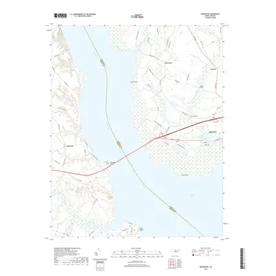
2019 Map of Edenhouse
USGS Topo · Published 2019About this map
The Chowan River serves as the central divide between Chowan and Bertie Counties, opening into the expansive waters of Albemarle Sound at the southern edge of this region. On the eastern shore, the town of Edenton serves as a focal point of commerce and residential growth, with neighborhoods branching off W Queen St and Oakridge Dr. To the north, the small settlements of Macedonia and Hancock are linked by Macedonia Rd, surrounded by low-lying wetland systems like Pollock Swamp. Across the river at Edenhouse Point, the landscape transitions toward the winding Salmon Creek and the riverfront community of Blackrock. This 2019 survey documents the bridge infrastructure connecting these banks and the persistence of family-named roads such as Jeff White Rd and Steele Place Ln that define the local genealogy of the North Carolina tidewater.
Find a feature on this map
61 named features on this map. Tap any name to fly to it.
Don’t see what you’re looking for? This feature index may not catch every label — zoom into the map to look around manually.
Map Details
Editions of this 2019 Edenhouse Map
This is the sole edition of this map. No revisions or reprints were ever made.
Other maps of this area

1904 · Edenton
USGS Topo · 1:62,500

1942 · Edenton
USGS Topo · 1:62,500

1943 · Plymouth
USGS Topo · 1:125,000

1943 · Edenton
USGS Topo · 1:62,500

1953 · Norfolk
USGS Topo · 1:250,000

1953 · Rocky Mount
USGS Topo · 1:250,000

1954 · Rocky Mount
USGS Topo · 1:250,000

1954 · Roper North
USGS Topo · 1:24,000

1954 · Westover
USGS Topo · 1:24,000
1979 · Woodard
USGS Topo · 1:24,000