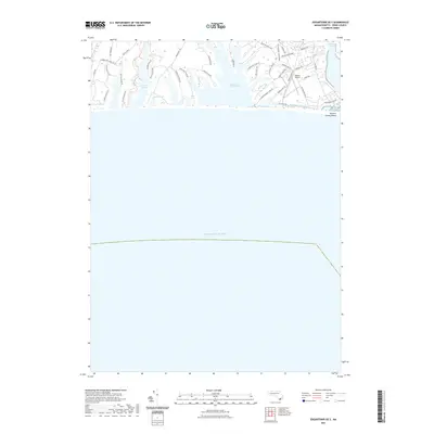
2021 Map of Edgartown OE S
USGS Topo · Published 2021About this map
The south shore of Martha's Vineyard is defined by its expansive coastal ponds and the finger-like peninsulas that separate them. Edgartown Great Pond dominates the eastern landscape, fed by numerous inlets such as Crackatucket Cove Rd and Slough Cove Rd. To the west, Oyster Pond and Paqua Pond mirror this geological pattern, separated by the landform of Jobs Neck. The map illustrates a network of historic thoroughfares and named family tracks, including Watcha Path, Scrubby Neck Farm Rd, and Meetinghouse Way.
Find a feature on this map
45 named features on this map. Tap any name to fly to it.
Don’t see what you’re looking for? This feature index may not catch every label — zoom into the map to look around manually.
Map Details
Editions of this 2021 Edgartown OE S Map
This is the sole edition of this map. No revisions or reprints were ever made.
Other maps of this area

1887 · Marthas Vineyard
USGS Topo · 1:62,500

1889 · Marthas Vineyard
USGS Topo · 1:62,500

1894 · Marthas Vineyard
USGS Topo · 1:62,500

1942 · Marthas Vineyard
USGS Topo · 1:125,000

1942 · Nantucket
USGS Topo · 1:125,000

1944 · Tisbury Great Pond
USGS Topo · 1:31,680

1944 · Vineyard Haven
USGS Topo · 1:31,680
1944 · Edgartown
USGS Topo · 1:31,680

1947 · Providence
USGS Topo · 1:250,000

1948 · Providence
USGS Topo · 1:250,000