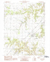
1985 Map of Edgewood
USGS Topo · Published 1985About this map
Edgewood serves as a central hub in this mid-1980s landscape, positioned where the Illinois Central Gulf railroad cuts a diagonal line through the prairie. The settlement pattern follows the rail corridor, connecting Mason in the northeast to La Clede in the southwest. This geography highlights the enduring importance of rail transport to the small agricultural communities of Effingham and Clay counties. Surrounding these towns, the terrain is defined by a dendritic network of waterways including Fulfer Creek and Dismal Creek, which carve through the otherwise level farm fields.
Find a feature on this map
17 named features on this map. Tap any name to fly to it.
Don’t see what you’re looking for? This feature index may not catch every label — zoom into the map to look around manually.
Map Details
Editions of this 1985 Edgewood Map
This is the sole edition of this map. No revisions or reprints were ever made.
Other maps of this area

1941 · St. Elmo
USGS Topo · 1:62,500

1945 · St. Elmo
USGS Topo · 1:62,500

1945 · Kinmundy
USGS Topo · 1:62,500

1947 · Kinmundy
USGS Topo · 1:62,500

1950 · Effingham
USGS Topo · 1:62,500

1951 · Effingham
USGS Topo · 1:62,500

1956 · Edgewood
USGS Topo · 1:62,500

1958 · Decatur
USGS Topo · 1:250,000

1958 · Belleville
USGS Topo · 1:250,000

1961 · Decatur
USGS Topo · 1:250,000