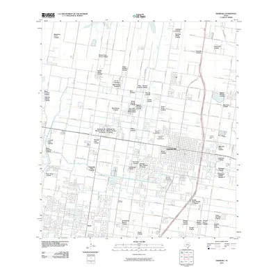
2010 Map of Edinburg
USGS Topo · Published 2010About this map
The University of Texas - Pan American campus dominates the central landscape of this 2010 survey of Hidalgo County, surrounded by a dense network of residential colonias. The settlement pattern reflects the rapid growth of the Rio Grande Valley, characterized by numerous small communities such as Simpatico Acres Colonia, Sauceda Colonia, and Americana Colonia. The local economy and infrastructure are highlighted by the presence of the Edinburg Gas Field and the vital irrigation systems of the Santa Cruz Canal and Edinburg East Main Canal. This detailed mapping shows the transition of traditional ranch or farmland into a suburban corridor, where established centers like Lull sit adjacent to newer developments like Monte Cristo Acres Colonia and the Edinburg Municipal Golf Course.
Find a feature on this map
92 named features on this map. Tap any name to fly to it.
Don’t see what you’re looking for? This feature index may not catch every label — zoom into the map to look around manually.
Map Details
Editions of this 2010 Edinburg Map
This is the sole edition of this map. No revisions or reprints were ever made.
Other maps of this area

1914 · San Juan
USGS Topo · 1:48,000

1916 · San Juan
USGS Topo · 1:62,500

1940 · Monte Christo
USGS Topo · 1:62,500

1949 · Mc Allen
USGS Topo · 1:250,000

1954 · McAllen
USGS Topo · 1:250,000

1957 · Mc Allen
USGS Topo · 1:250,000

1962 · McAllen
USGS Topo · 1:250,000

1963 · Monte Christo
USGS Topo · 1:24,000
1963 · Hargill
USGS Topo · 1:24,000

1963 · Edinburg
USGS Topo · 1:24,000