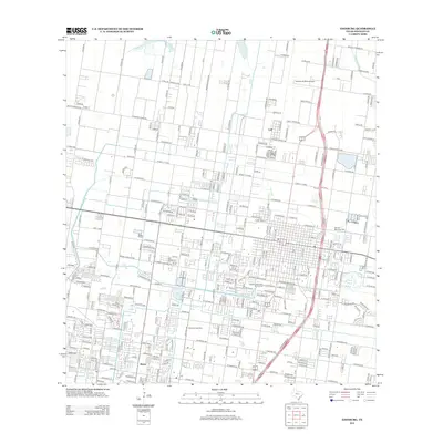
2012 Map of Edinburg
USGS Topo · Published 2012About this map
Edinburg and its surrounding Hidalgo County landscape are defined by a complex grid of agriculture and irrigation, notably the Edinburg Main Canal and the Santa Cruz Canal. The community of Lull sits to the north, while Merito is located in the southwestern portion of the map, illustrating the persistent small-settlement patterns of the Rio Grande Valley. Local industry is represented by the Edinburg Gas Field, a reminder of the region's energy resources. Civil infrastructure is well-marked, including the Norman & White Airport and the green space of the Edinburg Municipal Golf Course. For those tracing local heritage, the map identifies significant burial sites like the Old Edinburg Cem and the larger Hillcrest Memorial Park. The dense network of "Mile" roads and named avenues reveals a landscape meticulously organized for both residential growth and irrigated farming.
Find a feature on this map
269 named features on this map. Tap any name to fly to it.
Don’t see what you’re looking for? This feature index may not catch every label — zoom into the map to look around manually.
Map Details
Editions of this 2012 Edinburg Map
This is the sole edition of this map. No revisions or reprints were ever made.
Other maps of this area

1914 · San Juan
USGS Topo · 1:48,000

1916 · San Juan
USGS Topo · 1:62,500

1940 · Monte Christo
USGS Topo · 1:62,500

1949 · Mc Allen
USGS Topo · 1:250,000

1954 · McAllen
USGS Topo · 1:250,000

1957 · Mc Allen
USGS Topo · 1:250,000

1962 · McAllen
USGS Topo · 1:250,000

1963 · Monte Christo
USGS Topo · 1:24,000
1963 · Hargill
USGS Topo · 1:24,000

1963 · Edinburg
USGS Topo · 1:24,000