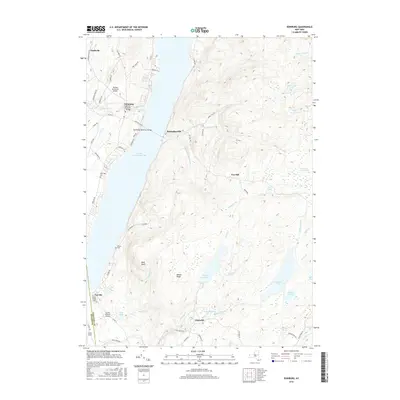
2016 Map of Edinburg
USGS Topo · Published 2016About this map
Edinburg and Batchellerville stand on opposite shores of Great Sacandaga Lake, connected by the prominent Sacandaga Reservoir Bridge. This 2016 survey illustrates the local topography of the southern Adirondack foothills, where the flooded valley of the Sacandaga River creates a significant water body that dominates the western landscape. Notable historic landmarks include the Copeland Covered Bridge near Beecher Cr, a site of local heritage value. To the east, the terrain rises sharply toward Fox Hill and Maxon Ridge, a region characterized by a high concentration of wetlands and smaller water bodies like Steele Reservoir, Ireland Vly, and Thousand Acre Swamp. Small rural settlements such as Fayville and Glenwild are documented along with family-named infrastructure, including Partridge Cem and Brooks Cem, which offer significant data for those researching the genealogy of Fulton and Saratoga counties.
Find a feature on this map
79 named features on this map. Tap any name to fly to it.
Don’t see what you’re looking for? This feature index may not catch every label — zoom into the map to look around manually.
Map Details
Editions of this 2016 Edinburg Map
This is the sole edition of this map. No revisions or reprints were ever made.
Other maps of this area

1899 · Broadalbin
USGS Topo · 1:62,500

1902 · Broadalbin
USGS Topo · 1:62,500

1902 · Saratoga
USGS Topo · 1:62,500

1903 · Luzerne
USGS Topo · 1:62,500

1910 · Stony Creek
USGS Topo · 1:62,500

1935 · Middle Grove
USGS Topo · 1:24,000

1942 · Saratoga
USGS Topo · 1:62,500

1945 · Edinburg
USGS Topo · 1:24,000
1945 · Galway
USGS Topo · 1:24,000

1945 · Northville
USGS Topo · 1:24,000