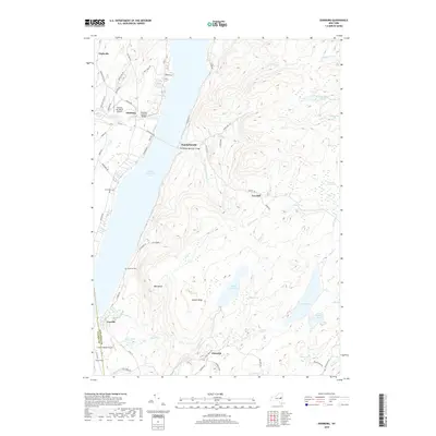
2019 Map of Edinburg
USGS Topo · Published 2019About this map
Great Sacandaga Lake dominates the central landscape of this Adirondack foothills region, where the historic settlements of Edinburg and Batchellerville are linked by the Sacandaga Reservoir Bridge. The terrain transitions from the open water and shoreline communities to the high, wooded ridges of Horse Hill and Bald Bluff. Local history is preserved in the detailed marking of the Copeland Covered Bridge over Beecher Cr, alongside rural resting places like Partridge Cem and Anderson Cem. The map illustrates a mix of recreation and aviation, featuring the Plateau Sky Ranch Airport and Circle K Ranch Airport near the border of Fulton and Saratoga counties. Small communities such as Glenwild and Fayville are situated among a complex network of wetlands and streams, including Thousand Acre Swamp and the headwaters of Steele Cr, reflecting the area's enduring rural and wilderness character.
Find a feature on this map
79 named features on this map. Tap any name to fly to it.
Don’t see what you’re looking for? This feature index may not catch every label — zoom into the map to look around manually.
Map Details
Editions of this 2019 Edinburg Map
This is the sole edition of this map. No revisions or reprints were ever made.
Other maps of this area

1899 · Broadalbin
USGS Topo · 1:62,500

1902 · Broadalbin
USGS Topo · 1:62,500

1902 · Saratoga
USGS Topo · 1:62,500

1903 · Luzerne
USGS Topo · 1:62,500

1910 · Stony Creek
USGS Topo · 1:62,500

1935 · Middle Grove
USGS Topo · 1:24,000

1942 · Saratoga
USGS Topo · 1:62,500

1945 · Edinburg
USGS Topo · 1:24,000
1945 · Galway
USGS Topo · 1:24,000

1945 · Northville
USGS Topo · 1:24,000