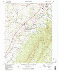
1994 Map of Edinburg
USGS Topo · Published 1997About this map
The North Fork Shenandoah River winds through the heart of the Shenandoah Valley, carving deep meanders between the mountain ridges of the George Washington National Forest. The town of Edinburg and the southern edge of Woodstock serve as the primary anchors of settlement, connected by the Norfolk and Western railroad and the modern highway corridor. This landscape is defined by the sharp transition from the fertile river bottoms to the steep slopes of Powell Mountain and Short Mountain, where the Fort Valley remains isolated by the high ridges of Bowman Mtn. Local history is preserved in rural crossroads like Lantz Mills and Wakemans Grove, and through institutional landmarks such as the Massanutten Military Academy and Central High Sch. From the Edinburg Reservoir to the Narrow Passage and Chapman Landing, the map illustrates a region where transportation routes have long been dictated by the narrow gaps and river bends of the valley.
Find a feature on this map
45 named features on this map. Tap any name to fly to it.
Don’t see what you’re looking for? This feature index may not catch every label — zoom into the map to look around manually.
Map Details
Editions of this 1994 Edinburg Map
This is the sole edition of this map. No revisions or reprints were ever made.
Other maps of this area

1892 · Woodstock
USGS Topo · 1:125,000

1893 · Luray
USGS Topo · 1:125,000

1905 · Luray
USGS Topo · 1:125,000

1923 · Edinburg
USGS Topo · 1:62,500

1929 · Stony Man
USGS Topo · 1:48,000

1933 · Stony Man
USGS Topo · 1:62,500

1942 · Mt Jackson
USGS Topo · 1:62,500

1946 · Mt Jackson
USGS Topo · 1:62,500

1947 · Mt Jackson
USGS Topo · 1:62,500

1947 · Strasburg
USGS Topo · 1:62,500