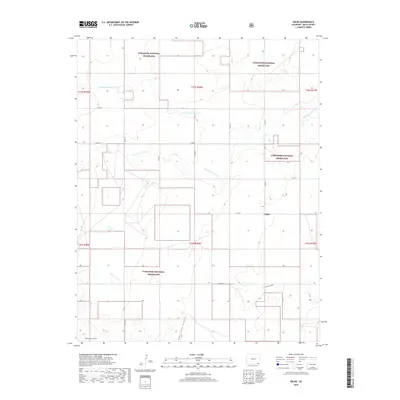
2019 Map of Edler
USGS Topo · Published 2019About this map
Comanche National Grassland dominates this corner of Baca County, where the high plains of Southeast Colorado are defined by a network of seasonal drainages. The small settlement of Edler serves as the central point of a grid-iron road system, where routes like Co RD P and Co RD 17 navigate the open prairie. The landscape is deeply incised by the erosive forces of the Sand Arroyo system, including the N Fork Sand Arroyo and the S Fork Sand Arroyo. Further south, the terrain becomes more complex as it drops into the canyonlands, specifically through the drainage of North Ute Canyon and the rugged basins of East Sand Canyon and Middle Sand Canyon. This map captures the intersection of federal conservation lands and the agricultural township-and-range lines that have shaped the region's ranching history for generations.
Find a feature on this map
27 named features on this map. Tap any name to fly to it.
Don’t see what you’re looking for? This feature index may not catch every label — zoom into the map to look around manually.
Map Details
Editions of this 2019 Edler Map
This is the sole edition of this map. No revisions or reprints were ever made.
Other maps of this area

1891 · Springfield
USGS Topo · 1:125,000

1893 · Springfield
USGS Topo · 1:125,000

1955 · La Junta
USGS Topo · 1:250,000

1958 · La Junta
USGS Topo · 1:250,000

1968 · La Junta
USGS Topo · 1:250,000

1978 · Edler
USGS Topo · 1:24,000

1978 · Pritchett
USGS Topo · 1:24,000

1978 · Springfield SW
USGS Topo · 1:24,000
1978 · Campo SW
USGS Topo · 1:24,000
1978 · Lone Rock
USGS Topo · 1:24,000