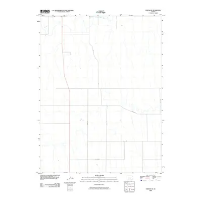
2009 Map of Edmond SE
USGS Topo · Published 2009About this map
Edmond anchors the northern edge of this Kansas landscape, situated near the winding course of the North Fork Solomon River. The area is characterized by a dense network of watercourses and rural roads that delineate the agricultural layout of Norton County in the early 21st century. Otter Cr feeds into the main river valley from the north, while further south, Bow Creek meanders across the plains, creating a distinct riparian drainage pattern. This topographic study by the U.S. Geological Survey details a landscape structured by the Public Land Survey System, where modern county routes like Co RD 362 and Co RD 553 follow section lines, connecting the few scattered farmsteads to the central hub of Edmond.
Find a feature on this map
11 named features on this map. Tap any name to fly to it.
Don’t see what you’re looking for? This feature index may not catch every label — zoom into the map to look around manually.
Map Details
Editions of this 2009 Edmond SE Map
This is the sole edition of this map. No revisions or reprints were ever made.
Other maps of this area

1893 · Norton
USGS Topo · 1:125,000

1893 · Hill
USGS Topo · 1:125,000

1955 · Beloit
USGS Topo · 1:250,000

1959 · Beloit
USGS Topo · 1:250,000

1978 · Edmond
USGS Topo · 1:24,000

1978 · Lenora East
USGS Topo · 1:24,000
1978 · Densmore
USGS Topo · 1:24,000
1978 · Edmond NW
USGS Topo · 1:24,000

1978 · Edmond SE
USGS Topo · 1:24,000
1979 · Logan SW
USGS Topo · 1:24,000