
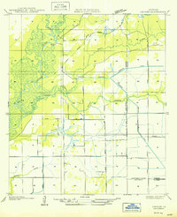
1947 Map of Edna
USGS Topo · Published 1947About this map
The Calcasieu River meanders through the heart of this southwest Louisiana landscape, marking a transition between the wetlands and the rising timber and agricultural lands of the mid-1930s. Small rail-side communities like Edna and Deaton Spur anchor the transport network, while Indian Village sits along a bend in the river, suggesting older patterns of settlement. The boundary between Allen Parish and Jefferson Davis Parish cuts horizontally across the sheet, dividing a region defined by its bayous and early industry.
Find a feature on this map
15 named features on this map. Tap any name to fly to it.
Don’t see what you’re looking for? This feature index may not catch every label — zoom into the map to look around manually.
Map Details
Editions of this 1947 Edna Map
This is the sole edition of this map. No revisions or reprints were ever made.
Other maps of this area

1947 · Kinder
USGS Topo · 1:31,680

1947 · Fenton
USGS Topo · 1:31,680

1947 · Oberlin
USGS Topo · 1:31,680

1947 · Hecker
USGS Topo · 1:31,680

1947 · Pine Island
USGS Topo · 1:31,680

1947 · Le Blanc
USGS Topo · 1:31,680

1947 · Reeves
USGS Topo · 1:31,680

1947 · Thompson Bluff
USGS Topo · 1:31,680

1950 · Fenton
USGS Topo · 1:31,680
1950 · Hecker
USGS Topo · 1:31,680