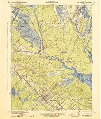
1942 Map of Egg Harbor
USGS Topo · Published 1942About this map
Egg Harbor City serves as the primary hub in this early 1940s survey of Atlantic and Burlington counties. The landscape is defined by the winding Mullica River and Batsto River, where historic industrial sites like Batsto and Pleasant Mills reflect the region's iron and glass-making heritage. A notable vestige of the First World War appears as an Abandoned World War Cantonment and the nearby Amotol Racetrack, signaling the transition of land use in the Pine Barrens. The area is heavily wooded, featuring the Green Bank State Forest and small settlements like Green Bank, Weekstown, and Elwood. Transportation is dominated by the Reading Seashore Lines and the Central RR of New Jersey, which connects the northern settlement of Atsion to the wider coastal network.
Find a feature on this map
79 named features on this map. Tap any name to fly to it.
Don’t see what you’re looking for? This feature index may not catch every label — zoom into the map to look around manually.
Map Details
Editions of this 1942 Egg Harbor Map
This is the sole edition of this map. No revisions or reprints were ever made.
Other maps of this area

1884 · Whitings
USGS Topo · 1:62,500

1887 · Atlantic City
USGS Topo · 1:62,500

1888 · Pemberton
USGS Topo · 1:62,500

1888 · Little Egg Harbor
USGS Topo · 1:62,500

1888 · Mount Holly
USGS Topo · 1:62,500

1888 · Whitings
USGS Topo · 1:62,500

1890 · Great Egg Harbor
USGS Topo · 1:62,500

1890 · Hammonton
USGS Topo · 1:62,500

1890 · Tuckahoe
USGS Topo · 1:62,500

1890 · Mullica
USGS Topo · 1:62,500