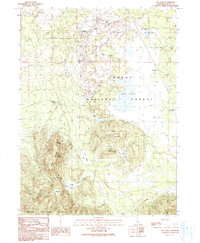
1990 Map of Egg Lake
USGS Topo · Published 1990About this map
Modoc National Forest encompasses this high-country landscape, where the seasonal waters of Egg Lake and Little Egg Lake sit amidst a complex of volcanic landforms and managed ranchlands. The area is defined by its water management history, evidenced by features like the Lost Reservoir, Ben Eberli Well, and Ben Eberli Waterhole. The presence of the Old Baker Cabin and the site at Demuth point to the early pioneer and ranching settlement of this part of Modoc County.
Find a feature on this map
33 named features on this map. Tap any name to fly to it.
Don’t see what you’re looking for? This feature index may not catch every label — zoom into the map to look around manually.
Map Details
Editions of this 1990 Egg Lake Map
This is the sole edition of this map. No revisions or reprints were ever made.
Other maps of this area

1886 · Modoc Lava Bed
USGS Topo · 1:250,000

1892 · Modoc Lava-Bed
USGS Topo · 1:250,000

1954 · Alturas
USGS Topo · 1:250,000

1958 · Alturas
USGS Topo · 1:250,000

1961 · Bieber
USGS Topo · 1:62,500

1961 · Fall River Mills
USGS Topo · 1:62,500

1962 · Alturas
USGS Topo · 1:250,000

1962 · Crank Mountain
USGS Topo · 1:62,500

1962 · White Horse
USGS Topo · 1:62,500

1965 · Alturas
USGS Topo · 1:250,000