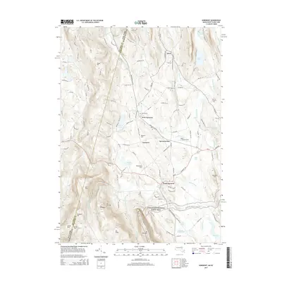
2015 Map of Egremont
USGS Topo · Published 2015About this map
South Egremont and the clustered settlements of Egremont sit at the foot of the Taconic Range along the Massachusetts and New York border. This terrain is defined by its water and high peaks, with Green River and Seekonk Brook winding through the lowlands between Mt Fray and Vossburg Hill. The map shows a clear distinction between the agricultural valley floors, such as Egremont Plain, and the steep, preserved slopes to the south and west. Significant landmarks include the Walter J. Koladza Airport and the campus of Bard Coll at Simon's Rock near the eastern edge. Along the southern ridges, the Appalachian National Scenic Trail traverses the summits of Mt Bushnell and Jug End, offering a detailed view of the corridor preserved for conservation. Local history is anchored by sites like Riverside Cem and the residential growth radiating from the village centers.
Find a feature on this map
127 named features on this map. Tap any name to fly to it.
Don’t see what you’re looking for? This feature index may not catch every label — zoom into the map to look around manually.
Map Details
Editions of this 2015 Egremont Map
This is the sole edition of this map. No revisions or reprints were ever made.
Other maps of this area

1885 · Sheffield
USGS Topo · 1:62,500

1888 · Sheffield
USGS Topo · 1:62,500

1888 · Pittsfield
USGS Topo · 1:62,500

1890 · Pittsfield
USGS Topo · 1:62,500

1891 · Sheffield
USGS Topo · 1:62,500

1893 · Sheffield
USGS Topo · 1:62,500

1893 · Pittsfield
USGS Topo · 1:62,500

1894 · Pittsfield
USGS Topo · 1:62,500

1897 · Pittsfield
USGS Topo · 1:62,500

1897 · Sheffield
USGS Topo · 1:62,500