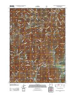
2011 Map of Eight Dollar Mountain
USGS Topo · Published 2011About this map
Eight Dollar Mountain and the surrounding terrain of Josephine County define this landscape, where the Illinois River flows through a series of significant flats and gulches. The area shows a clear history of resource extraction, with the Eureka Mine and Anderson Mine situated among the drainage basins of Horse Creek and Ellis Creek. Small settlements and industrial points like Spaulding Mill, Kerby Flat, and Star Flat are connected by forest routes such as Serpentine Rd and Illinois River Rd. This survey captures the complex topography of the Klamath Mountains region, evidenced by numerous named features like Store Gulch, Pockett Knoll, and Serpentine Point. The presence of Cedar Gulch and Alder Gulch near the riverbanks suggests a diverse riparian environment that once supported the local mining and milling operations.
Find a feature on this map
41 named features on this map. Tap any name to fly to it.
Don’t see what you’re looking for? This feature index may not catch every label — zoom into the map to look around manually.
Map Details
Editions of this 2011 Eight Dollar Mountain Map
This is the sole edition of this map. No revisions or reprints were ever made.
Other maps of this area

1917 · Kerby
USGS Topo · 1:125,000

1918 · Kerby
USGS Topo · 1:125,000

1945 · Kerby
USGS Topo · 1:125,000

1954 · Cave Junction
USGS Topo · 1:62,500

1954 · Selma
USGS Topo · 1:62,500

1954 · Chetco Peak
USGS Topo · 1:62,500

1954 · Pearsoll Peak
USGS Topo · 1:62,500

1955 · Medford
USGS Topo · 1:250,000

1957 · Medford
USGS Topo · 1:250,000

1958 · Medford
USGS Topo · 1:250,000