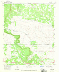
1966 Map of El Cabo
USGS Topo · Published 1970About this map
Ortiz Ranch and Rancho del Venado anchor this high-desert landscape in the mid-1960s, a period when cattle ranching and water management were central to life on the New Mexico plains. The terrain is dominated by the dramatic rise of Mesa Las Tapia and the prominent peak of El Cabo, which overlooks a complex system of livestock watering holes. This network includes the Tapia Tank No 1, School Tank, and Alasan Tank, illustrating the critical role of surface water catchment in this arid environment. The map also delineates the jurisdictional boundary between San Miguel and Torrance counties as it cuts across the rugged topography. Economic activity of the era is evidenced by scattered Gravel Pits and a Borrow Pit along the southern road, while the namesake Rincon Agua Verde provides a distinct geographical focus for the northern reaches of the quadrangle.
Find a feature on this map
30 named features on this map. Tap any name to fly to it.
Don’t see what you’re looking for? This feature index may not catch every label — zoom into the map to look around manually.
Map Details
Editions of this 1966 El Cabo Map
This is the sole edition of this map. No revisions or reprints were ever made.
Other maps of this area

1890 · Bernal
USGS Topo · 1:125,000

1891 · Bernal
USGS Topo · 1:125,000

1894 · Bernal
USGS Topo · 1:125,000

1894 · Lamy
USGS Topo · 1:125,000

1954 · Santa Fe
USGS Topo · 1:250,000

1954 · Fort Sumner
USGS Topo · 1:250,000

1958 · Fort Sumner
USGS Topo · 1:250,000

1958 · Santa Fe
USGS Topo · 1:250,000

1963 · Jacinto Mesa
USGS Topo · 1:24,000

1963 · Aurora
USGS Topo · 1:24,000