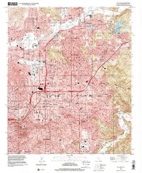
1996 Map of El Cajon
USGS Topo · Published 2001About this map
El Cajon and its surrounding valleys appear here in a state of dense residential and commercial expansion, captured at the close of the 20th century. The suburban landscape is punctuated by a high concentration of educational and religious institutions, including Granite Hills High Sch, Our Lady of Perpetual Help Sch, and the Convent of the Sacred Heart. To the north, the San Diego River passes through Lakeside, where community landmarks like Lindo Lake and Cactus County Park provide recreational breaks in the grid. The map also highlights the area's aviation and automotive history through Gillespie Field and the nearby Cajon Speedway. Beyond the city limits, the terrain transitions into the steep slopes of Hidden Mesa and the Sweetwater River valley, where the suburban pattern gives way to the open spaces of Jamacha Valley.
Find a feature on this map
78 named features on this map. Tap any name to fly to it.
Don’t see what you’re looking for? This feature index may not catch every label — zoom into the map to look around manually.
Map Details
Editions of this 1996 El Cajon Map
This is the sole edition of this map. No revisions or reprints were ever made.
Other maps of this area

1893 · El Cajon
USGS Topo · 1:62,500

1901 · Elcajon
USGS Topo · 1:62,500

1903 · Cuyamaca
USGS Topo · 1:125,000

1903 · La Jolla
USGS Topo · 1:62,500

1903 · Elcajon
USGS Topo · 1:62,500

1904 · San Diego
USGS Topo · 1:62,500

1904 · Southern California Sheet No. 2
USGS Topo · 1:250,000

1930 · La Jolla
USGS Topo · 1:62,500

1930 · San Diego
USGS Topo · 1:62,500

1939 · El Cajon
USGS Topo · 1:62,500