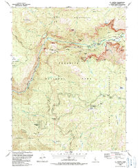
1990 Map of El Capitan
USGS Topo · Published 1990About this map
El Capitan and the sheer verticality of the Gorge of the Merced dominate this survey, capturing the gateway to the valley floor as it was managed in the late 1980s. The map details the developed infrastructure of the high country, from the Badger Pass Ski Area and its lifts to the concentrated residential pockets at Yosemite West and Foresta. Beyond the granite monoliths, the presence of a Quarry near Monroe Meadows and various Radio Facilities atop Turtleback Dome reflect the practical maintenance and communication needs of the Yosemite National Park interior.
Find a feature on this map
75 named features on this map. Tap any name to fly to it.
Don’t see what you’re looking for? This feature index may not catch every label — zoom into the map to look around manually.
Map Details
Editions of this 1990 El Capitan Map
This is the sole edition of this map. No revisions or reprints were ever made.
Other maps of this area

1897 · Yosemite
USGS Topo · 1:125,000

1900 · Yosemite
USGS Topo · 1:125,000

1903 · Yosemite
USGS Topo · 1:125,000

1909 · Yosemite
USGS Topo · 1:125,000

1947 · El Portal
USGS Topo · 1:24,000

1947 · Mariposa
USGS Topo · 1:250,000

1947 · El Portal
USGS Topo · 1:62,500

1947 · Buckingham Mtn
USGS Topo · 1:24,000

1948 · Mariposa
USGS Topo · 1:250,000
1949 · Buckingham Mtn
USGS Topo · 1:24,000