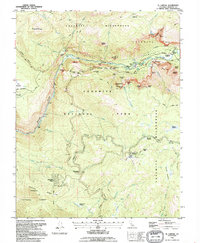
1992 Map of El Capitan
USGS Topo · Published 1995About this map
El Capitan stands as the towering focal point of this survey, overlooking the western reaches of the Yosemite Valley. The map details the complex transportation and recreation infrastructure of Yosemite National Park in the early 1990s, from the developed slopes of the Badger Pass Ski Area to the historic Old Coulterville Road. The settlement patterns of Foresta and Yosemite West contrast with the protected expanse of the Yosemite Wilderness, while the southern half of the sheet shows the transition into the Sierra National Forest along Henness Ridge. Visitors entering via the Arch Rock Entrance would find the Merced River carving through the Merced Gorge, flanked by world-renowned granite features like the Cathedral Spires and the Leaning Tower. This edition records the area before significant changes to the Wawona Road and park facilities occurred in the late 20th century.
Find a feature on this map
69 named features on this map. Tap any name to fly to it.
Don’t see what you’re looking for? This feature index may not catch every label — zoom into the map to look around manually.
Map Details
Editions of this 1992 El Capitan Map
This is the sole edition of this map. No revisions or reprints were ever made.
Other maps of this area

1897 · Yosemite
USGS Topo · 1:125,000

1900 · Yosemite
USGS Topo · 1:125,000

1903 · Yosemite
USGS Topo · 1:125,000

1909 · Yosemite
USGS Topo · 1:125,000

1947 · El Portal
USGS Topo · 1:24,000

1947 · Mariposa
USGS Topo · 1:250,000

1947 · El Portal
USGS Topo · 1:62,500

1947 · Buckingham Mtn
USGS Topo · 1:24,000

1948 · Mariposa
USGS Topo · 1:250,000
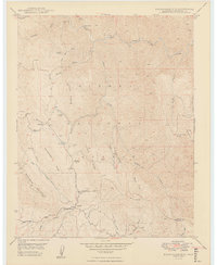
1949 · Buckingham Mtn
USGS Topo · 1:24,000