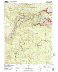
1997 Map of El Capitan
USGS Topo · Published 2002About this map
El Capitan towers over the Merced River in this late 20th-century survey of the valley's western gateway. The map details the transition from the vertical walls of Cathedral Rocks and the Cathedral Spires to the high meadows and forests of the Yosemite Wilderness. Infrastructure for modern park management is evident, including the Arch Rock Entrance, Radio Facilities, and a Sewage Disposal Pond near the valley floor.
Find a feature on this map
79 named features on this map. Tap any name to fly to it.
Don’t see what you’re looking for? This feature index may not catch every label — zoom into the map to look around manually.
Map Details
Editions of this 1997 El Capitan Map
This is the sole edition of this map. No revisions or reprints were ever made.
Other maps of this area

1897 · Yosemite
USGS Topo · 1:125,000

1900 · Yosemite
USGS Topo · 1:125,000

1903 · Yosemite
USGS Topo · 1:125,000

1909 · Yosemite
USGS Topo · 1:125,000

1947 · El Portal
USGS Topo · 1:24,000

1947 · Mariposa
USGS Topo · 1:250,000

1947 · El Portal
USGS Topo · 1:62,500

1947 · Buckingham Mtn
USGS Topo · 1:24,000

1948 · Mariposa
USGS Topo · 1:250,000
1949 · Buckingham Mtn
USGS Topo · 1:24,000