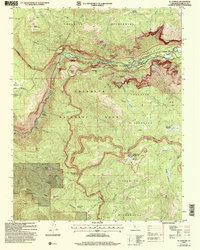
2004 Map of El Capitan
USGS Topo · Published 2007About this map
El Capitan stands as the dominant granite monolith over the Merced River in this 2004 revision, which details the iconic verticality and glacial carved features of the western valley. This study captures the high-country landscape just after the turn of the century, showing the intricate trail systems and seasonal waterways that define the region. High-elevation meadows like Summit Meadow and McGurk Meadow are mapped alongside the dramatic drops of Bridalveil Fall and Ribbon Fall.
Find a feature on this map
62 named features on this map. Tap any name to fly to it.
Don’t see what you’re looking for? This feature index may not catch every label — zoom into the map to look around manually.
Map Details
Editions of this 2004 El Capitan Map
This is the sole edition of this map. No revisions or reprints were ever made.
Other maps of this area

1897 · Yosemite
USGS Topo · 1:125,000

1900 · Yosemite
USGS Topo · 1:125,000

1903 · Yosemite
USGS Topo · 1:125,000

1909 · Yosemite
USGS Topo · 1:125,000

1947 · El Portal
USGS Topo · 1:24,000

1947 · Mariposa
USGS Topo · 1:250,000

1947 · El Portal
USGS Topo · 1:62,500

1947 · Buckingham Mtn
USGS Topo · 1:24,000

1948 · Mariposa
USGS Topo · 1:250,000
1949 · Buckingham Mtn
USGS Topo · 1:24,000