
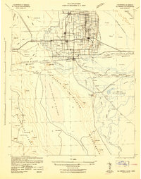
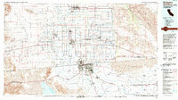
1955 Map of El Centro
USGS Topo · Published 1955This historical map portrays the area of El Centro in 1955, primarily covering Imperial County as well as portions of Arizona. Featuring a scale of 1:250000, this map provides a highly detailed snapshot of the terrain, roads, buildings, counties, and historical landmarks in the El Centro region at the time. Published in 1955, it is the sole known edition of this map.
Find a feature on this map
139 named features on this map. Tap any name to fly to it.
Don’t see what you’re looking for? This feature index may not catch every label — zoom into the map to look around manually.
Map Details
Editions of this 1955 El Centro Map
This is the sole edition of this map. No revisions or reprints were ever made.
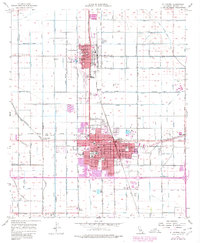
Historical Maps of Donovan Estates Through Time
10 maps found

1915 El Centro
Imperial County, CA
1942 El Centro
Imperial County, CA

1954 El Centro
Imperial County, CA
1955 El Centro
Imperial County, CA
1957 El Centro
Imperial County, CA
1958 El Centro
Imperial County, CA

1961 El Centro
Imperial County, CA

1964 El Centro
Imperial County, CA
1976 El Centro
Imperial County, CA
1989 El Centro
Imperial County, CA