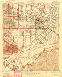
1948 Map of El Monte
USGS Topo · Published 1948About this map
Rosemead Lodge Sanitarium and the sprawling grid of the San Gabriel Valley define this landscape during a period of rapid post-war suburban transformation. While the Southern Pacific and Pacific Electric lines still cut through the territory, the shift toward an automobile-centric society is evident in the detailed labeling of thoroughfares like Valley Boulevard and Garvey Ave. The map preserves the transition between old ranchos and new neighborhoods, noting historic land grants like Potrero de Felipe Lugo alongside mid-century landmarks like the Radio Sta and the Airway Beacon in the La Merced hills.
Find a feature on this map
54 named features on this map. Tap any name to fly to it.
Don’t see what you’re looking for? This feature index may not catch every label — zoom into the map to look around manually.
Map Details
Editions of this 1948 El Monte Map
This is the sole edition of this map. No revisions or reprints were ever made.
Other maps of this area

1894 · Los Angeles
USGS Topo · 1:62,500

1894 · Pomona
USGS Topo · 1:62,500

1896 · Pasadena
USGS Topo · 1:62,500

1896 · Anaheim
USGS Topo · 1:62,500

1896 · Downey
USGS Topo · 1:62,500

1897 · Pomona
USGS Topo · 1:62,500

1898 · Pomona
USGS Topo · 1:62,500

1898 · Anaheim
USGS Topo · 1:62,500

1899 · Downey
USGS Topo · 1:62,500

1900 · Pasadena
USGS Topo · 1:62,500