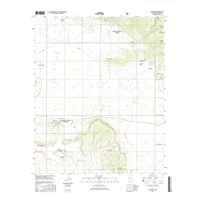
2017 Map of El Morro
USGS Topo · Published 2017About this map
El Morro National Monument anchors the southern portion of this landscape, preserving the massive sandstone promontory known simply as El Morro. This area in New Mexico is defined by high-elevation mesa country and the transition into the Cibola National Forest and the Zuni Mountains to the north. Settlement is sparse, centered around the small community of El Morro and the nearby Tinaja. Genealogy researchers will find both the El Morro Cem and Tinaja Cem clearly marked, along with a network of rural roads such as San Rafael Road and Indian Svc Rte 47. Significant natural landmarks including Woodpecker Arch and Obe Worthen Mesa punctuate the drainage systems of Muerto Canyon and Alamosa Canyon, illustrating the varied topography of this historic corridor.
Find a feature on this map
42 named features on this map. Tap any name to fly to it.
Don’t see what you’re looking for? This feature index may not catch every label — zoom into the map to look around manually.
Map Details
Editions of this 2017 El Morro Map
This is the sole edition of this map. No revisions or reprints were ever made.
Other maps of this area
1886 · Wingate
USGS Topo · 1:250,000
1892 · Wingate
USGS Topo · 1:250,000
1952 · Valle Largo
USGS Topo · 1:24,000
1952 · Post Office Flat
USGS Topo · 1:24,000

1954 · Saint Johns
USGS Topo · 1:250,000

1954 · Gallup
USGS Topo · 1:250,000

1957 · Saint Johns
USGS Topo · 1:250,000

1958 · Gallup
USGS Topo · 1:250,000

1958 · Saint Johns
USGS Topo · 1:250,000

1959 · Gallup
USGS Topo · 1:250,000
Featured Places
- Eastern Navajo Agency, NM
- Sand Corner, Eastern Navajo Agency
- Tinaja, Eastern Navajo Agency
- El Morro, Eastern Navajo Agency
- El Morro, Eastern Navajo Agency