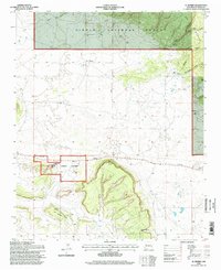
1995 Map of El Morro
USGS Topo · Published 1998About this map
El Morro National Monument dominates this mid-1990s landscape, centered on the ancient traveler's landmark known as Inscription Rock. The map illustrates a high-desert terrain shaped by deep cultural roots and livestock ranching, indicated by several scattered Corrals and reliable water sources like Caruco Spring and Ojo Bonito Canyon. Settled pockets such as Pueblito and Sand Corner are connected by a network of unimproved roads and a prominent Telephone line that cuts across the high mesa country. The transition from the Zuni Mountains to the broad, flat reaches of Obe Worthen Mesa highlights the varied topography of this section of the Cibola National Forest. Local history is anchored by the El Morro Cemetery and Tinaja Cemetery, providing essential geographic context for those researching early families who established homesteads near Charlie Barns Gap.
Find a feature on this map
22 named features on this map. Tap any name to fly to it.
Don’t see what you’re looking for? This feature index may not catch every label — zoom into the map to look around manually.
Map Details
Editions of this 1995 El Morro Map
This is the sole edition of this map. No revisions or reprints were ever made.
Other maps of this area

1886 · Wingate
USGS Topo · 1:250,000

1892 · Wingate
USGS Topo · 1:250,000

1952 · Valle Largo
USGS Topo · 1:24,000

1952 · Post Office Flat
USGS Topo · 1:24,000

1954 · Saint Johns
USGS Topo · 1:250,000

1954 · Gallup
USGS Topo · 1:250,000

1957 · Saint Johns
USGS Topo · 1:250,000

1958 · Gallup
USGS Topo · 1:250,000

1958 · Saint Johns
USGS Topo · 1:250,000

1959 · Gallup
USGS Topo · 1:250,000
Featured Places
- Eastern Navajo Agency, NM
- Sand Corner, Eastern Navajo Agency
- Tinaja, Eastern Navajo Agency
- El Morro, Eastern Navajo Agency
- El Morro, Eastern Navajo Agency