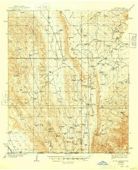
1940 Map of El Paso Gap
USGS Topo · Published 1948About this map
The Guadalupe Mountains dominate this high-desert landscape, where ranching life in the 1930s centered on vital water sources and family holdings. Settlement patterns are defined by dozens of catchment basins and tanks named for local families, including Ira Lewis Tank, Arch Lewis Tank, and the Thomas Ranch. The survey highlights the essential infrastructure of the era, such as the Queen Sch and Dog Canyon Sch, which served the remote ranching community. The terrain is a complex network of canyons and draws, from the depths of Big Dog Canyon to the heights of Plowman Peak. Strategic passes like El Paso Gap and Klondike Gap provided necessary passage through the limestone ridges, while the Carlsbad Road served as the primary terrestrial artery connecting these isolated mountain outposts.
Find a feature on this map
113 named features on this map. Tap any name to fly to it.
Don’t see what you’re looking for? This feature index may not catch every label — zoom into the map to look around manually.
Map Details
Editions of this 1940 El Paso Gap Map
3 editions found
Other maps of this area

1933 · Guadalupe Peak
USGS Topo · 1:48,000

1935 · El Paso Gap
USGS Topo · 1:62,500

1936 · El Paso Gap
USGS Topo · 1:48,000

1940 · El Paso Gap
USGS Topo · 1:62,500

1940 · Guadalupe Peak
USGS Topo · 1:62,500

1940 · Bandanna Point
USGS Topo · 1:62,500

1940 · Carlsbad Caverns West
USGS Topo · 1:62,500

1943 · Carlsbad Caverns West
USGS Topo · 1:62,500

1943 · Bandanna Point
USGS Topo · 1:62,500

1943 · Texas Hill
USGS Topo · 1:62,500