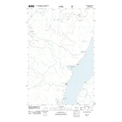
2011 Map of Eldon
USGS Topo · Published 2011About this map
The western shore of the Hood Canal defines this 2011 survey, where the Olympic Peninsula's steep drainage meets the salt water. The small coastal settlements of Eldon, Hamma Hamma, and Ayock are clustered along the shoreline, connected by a road network that transitions quickly from coastal transit to rugged forest access. The Hamma Hamma River is the primary waterway here, flowing past the Hamma Hamma Campground and beneath the North Hamma Hamma River Bridge before emptying into the canal. This landscape is a patchwork of recreational and industrial use, featuring landmarks like Mike's Beach Resort Recreational Vehicle Park alongside numerous National Forest roads such as NFD 25 RD and NFD 24 RD. Elevations rise sharply from the shoreline toward Webb Mountain and West Rock, with numerous creeks including Waketickeh Creek and Jorsted Creek cutting through the terrain.
Find a feature on this map
40 named features on this map. Tap any name to fly to it.
Don’t see what you’re looking for? This feature index may not catch every label — zoom into the map to look around manually.
Map Details
Editions of this 2011 Eldon Map
This is the sole edition of this map. No revisions or reprints were ever made.
Other maps of this area

1936 · Point Misery
USGS Topo · 1:62,500

1938 · Mt Constance
USGS Topo · 1:125,000

1938 · Allyn
USGS Topo · 1:62,500

1940 · Point Misery
USGS Topo · 1:62,500

1943 · Potlatch
USGS Topo · 1:62,500

1947 · The Brothers
USGS Topo · 1:62,500

1950 · The Brothers
USGS Topo · 1:62,500

1952 · Potlatch
USGS Topo · 1:62,500
1953 · Brinnon
USGS Topo · 1:24,000

1953 · Lake Wooten
USGS Topo · 1:24,000