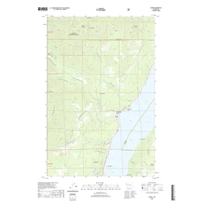
2020 Map of Eldon
USGS Topo · Published 2020About this map
The settlement of Eldon serves as the primary coastal anchor along the western shore of the Hood Canal, where the Hamma Hamma River meets the saltwater. This coastal landscape is defined by its transition from the steep, timbered ridges of the Olympic National Forest to the marine environment of the Great Peninsula. Interior landmarks like Webb Mtn and West Rock rise sharply from the drainage basins of Jefferson Cr and Waketicheh Cr, while the shoreline is punctuated by geographic markers such as Ayock Point, Cummings Point, and Chinom Point.
Find a feature on this map
48 named features on this map. Tap any name to fly to it.
Don’t see what you’re looking for? This feature index may not catch every label — zoom into the map to look around manually.
Map Details
Editions of this 2020 Eldon Map
This is the sole edition of this map. No revisions or reprints were ever made.
Other maps of this area

1936 · Point Misery
USGS Topo · 1:62,500

1938 · Mt Constance
USGS Topo · 1:125,000

1938 · Allyn
USGS Topo · 1:62,500

1940 · Point Misery
USGS Topo · 1:62,500

1943 · Potlatch
USGS Topo · 1:62,500

1947 · The Brothers
USGS Topo · 1:62,500

1950 · The Brothers
USGS Topo · 1:62,500

1952 · Potlatch
USGS Topo · 1:62,500
1953 · Brinnon
USGS Topo · 1:24,000

1953 · Lake Wooten
USGS Topo · 1:24,000