
1985 Map of Eldon
USGS Topo · Published 1985About this map
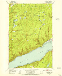
Olympic National Forest slopes down toward the western shore of Hood Canal in this mid-1980s landscape. The settlement of Eldon serves as the primary coastal point, situated near the mouth of Hamma Hamma River and the tidal flats of the canal. The map documents a transition between protected forest land and developed shorelines, with infrastructure such as the Hamma Hamma F S Station and the Hamms Hamma Campground supporting the region's relationship with the outdoors. Inland, the terrain is defined by a dense network of watercourses, including Waketickeh Creek and Jefferson Creek, alongside upland bodies of water like Lake Armstrong and Melbourne Lake. Industrial and utility footprints are visible through a Quarry near Cummings Point and multiple transmission corridors, including a Steel Tower Transmission Line that cuts through the forested ridges.
Find a feature on this map
33 named features on this map. Tap any name to fly to it.
Don’t see what you’re looking for? This feature index may not catch every label — zoom into the map to look around manually.
Map Details
Editions of this 1985 Eldon Map
This is the sole edition of this map. No revisions or reprints were ever made.
Other maps of this area

1936 · Point Misery
USGS Topo · 1:62,500

1938 · Mt Constance
USGS Topo · 1:125,000

1938 · Allyn
USGS Topo · 1:62,500

1940 · Point Misery
USGS Topo · 1:62,500

1943 · Potlatch
USGS Topo · 1:62,500

1947 · The Brothers
USGS Topo · 1:62,500

1950 · The Brothers
USGS Topo · 1:62,500
1952 · Potlatch
USGS Topo · 1:62,500
1953 · Brinnon
USGS Topo · 1:24,000
1953 · Lake Wooten
USGS Topo · 1:24,000