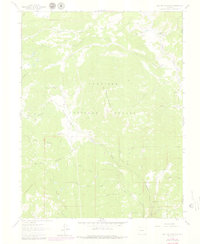
1961 Map of Electric Mountain
USGS Topo · Published 1979About this map
Electric Mountain and the high drainage basins of the Gunnison National Forest define this 1961 survey, which captures the intersection of working ranchlands and protected wilderness along the border of Delta and Gunnison counties. The landscape is marked by a complex network of hydrological features, from the high Overland Ditch to the intricate tributaries of the Hubbard Creek system, including Main Hubbard Creek, Middle Hubbard Creek, and West Hubbard Creek.
Find a feature on this map
45 named features on this map. Tap any name to fly to it.
Don’t see what you’re looking for? This feature index may not catch every label — zoom into the map to look around manually.
Map Details
Editions of this 1961 Electric Mountain Map
4 editions found
Other maps of this area

1938 · Mt. Gunnison
USGS Topo · 1:48,000

1945 · Mount Gunnison
USGS Topo · 1:62,500

1956 · Montrose
USGS Topo · 1:250,000

1957 · Leadville
USGS Topo · 1:250,000

1959 · Leadville
USGS Topo · 1:250,000

1959 · Montrose
USGS Topo · 1:250,000

1960 · Leadville
USGS Topo · 1:250,000

1960 · Montrose
USGS Topo · 1:250,000

1961 · Electric Mountain
USGS Topo · 1:24,000

1961 · Porter Mountain
USGS Topo · 1:24,000