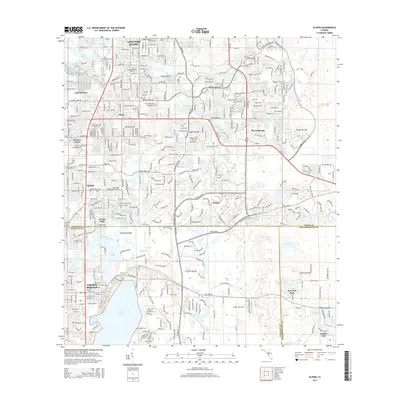
2015 Map of Elfers
USGS Topo · Published 2015About this map
New Port Richey and Tarpon Springs anchor this coastal Florida landscape at a time of extensive residential expansion and interconnected suburban development. The map details the complex hydrology of the Gulf Coast, following the winding Anclote River and the Pithlachascotee River as they move toward the coast, alongside notable water bodies like Lake Tarpon and Salt Lake. The transition from Pasco County into Pinellas and Hillsborough is marked by established communities like Elfers, Holiday, and the evolving educational campus of the Trinity College of Florida. Genealogists will find several significant burial grounds documented, including the East Elfers Cemetery and the sprawling Meadowlawn Memorial Gardens. The map also illustrates the modern infrastructure of SR-54 as it ties together the newer developments of Trinity and Seven Springs with the historic coastal settlements.
Find a feature on this map
41 named features on this map. Tap any name to fly to it.
Don’t see what you’re looking for? This feature index may not catch every label — zoom into the map to look around manually.
Map Details
Editions of this 2015 Elfers Map
This is the sole edition of this map. No revisions or reprints were ever made.
Other maps of this area

1943 · Dunedin
USGS Topo · 1:31,680

1943 · Tarpon Springs
USGS Topo · 1:31,680

1943 · Odessa
USGS Topo · 1:24,000

1943 · Elfers
USGS Topo · 1:24,000

1943 · Oldsmar
USGS Topo · 1:24,000

1944 · Elfers
USGS Topo · 1:31,680

1944 · Oldsmar
USGS Topo · 1:31,680

1944 · Odessa
USGS Topo · 1:31,680
1947 · Citrus Park
USGS Topo · 1:24,000

1948 · Elfers
USGS Topo · 1:25,000