
1943 Map of Oldsmar
USGS Topo · Published 1961About this map
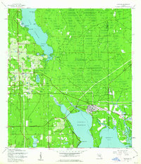
Oldsmar serves as the focal point of this coastal survey, situated where the Seaboard Air Line railroad meets the northern reaches of Safety Harbor. During the early 1940s, the landscape was a mix of citrus groves and wetlands, characterized by significant water bodies like Lake Tarpon and its various points, including Sandy Point and Wall Point. The rural character of northern Pinellas County is evident in scattered settlements such as Curlew, St George, and Bridgeport. Local community life is marked by the Curlew Ch and a Boy Scout Camp near Lake Bowden. Industry and transport are defined by the rail corridor, while the eastern edge transition toward Hillsborough County includes a Military Reservation and the winding course of Double Branch. This period captures the region before extensive modern suburbanization, showing a reliance on the existing railroad and natural drainage systems like Brooker Creek and Moccasin Creek.
Find a feature on this map
37 named features on this map. Tap any name to fly to it.
Don’t see what you’re looking for? This feature index may not catch every label — zoom into the map to look around manually.
Map Details
Editions of this 1943 Oldsmar Map
2 editions found
Other maps of this area

1921 · Sand Key
USGS Topo · 1:62,500

1921 · St Petersburg
USGS Topo · 1:62,500

1943 · Gandy Bridge
USGS Topo · 1:31,680

1943 · Safety Harbor
USGS Topo · 1:31,680

1943 · Dunedin
USGS Topo · 1:31,680

1943 · Tarpon Springs
USGS Topo · 1:31,680

1943 · Clearwater
USGS Topo · 1:24,000

1943 · Odessa
USGS Topo · 1:24,000

1943 · Elfers
USGS Topo · 1:24,000

1944 · Elfers
USGS Topo · 1:31,680