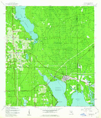
1943 Map of Oldsmar
USGS Topo · Published 1961About this map
The Oldsmar township serves as the hub of this 1943 survey, situated where the Seaboard Air Line railroad meets the upper reaches of Safety Harbor. The landscape is defined by its transition from the freshwater of Lake Tarpon in the northwest to the tidal flats and salt marshes of Mobbly Bay in the southeast. This era shows the region before the massive mid-century suburban expansion, featuring small localized settlements like Mecca, St George, and Bridgeport. Numerous creeks, including Brooker Creek, Moccasin Creek, and Curlew Creek, drain into the coastal basins, creating a complex network of wetlands. Landmarks of local importance, such as the Curlew Ch, the Boy Scout Camp on Lake Bowden, and a dedicated Military Reservation, provide specific points of interest for genealogists and local historians tracking the early development of Pinellas and Hillsborough counties.
Find a feature on this map
35 named features on this map. Tap any name to fly to it.
Don’t see what you’re looking for? This feature index may not catch every label — zoom into the map to look around manually.
Map Details
Editions of this 1943 Oldsmar Map
2 editions found
Other maps of this area

1921 · Sand Key
USGS Topo · 1:62,500

1921 · St Petersburg
USGS Topo · 1:62,500

1943 · Gandy Bridge
USGS Topo · 1:31,680

1943 · Safety Harbor
USGS Topo · 1:31,680

1943 · Dunedin
USGS Topo · 1:31,680

1943 · Tarpon Springs
USGS Topo · 1:31,680

1943 · Clearwater
USGS Topo · 1:24,000

1943 · Odessa
USGS Topo · 1:24,000

1943 · Elfers
USGS Topo · 1:24,000

1943 · Oldsmar
USGS Topo · 1:24,000