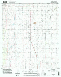
1996 Map of Elfrida
USGS Topo · Published 2003About this map
Elfrida serves as the central hub of this agricultural landscape in Cochise County, situated along Highway 191. The town's grid and proximity to the Mobile Home Park reflect a concentrated community surrounded by a vast network of irrigation and water management infrastructure. The terrain is defined by the prominent course of Whitewater Draw, which meanders from north to south across the valley floor. The map records a high density of wells and several Silos, illustrating the intensive groundwater reliance and storage requirements of the local ranching or farming economy during the late twentieth century. Landmark survey points like BM 4136 and the Substation north of town mark the technical development of the area, while the presence of Decca 7 indicates specialized navigation or communication installations in this part of the Arizona desert.
Find a feature on this map
22 named features on this map. Tap any name to fly to it.
Don’t see what you’re looking for? This feature index may not catch every label — zoom into the map to look around manually.
Map Details
Editions of this 1996 Elfrida Map
This is the sole edition of this map. No revisions or reprints were ever made.
Other maps of this area

1916 · Pearce
USGS Topo · 1:125,000

1922 · Swisshelm
USGS Topo · 1:62,500

1925 · Gleeson
USGS Topo · 1:62,500

1926 · Light
USGS Topo · 1:62,500

1926 · Courtland
USGS Topo · 1:62,500

1955 · Douglas
USGS Topo · 1:250,000

1958 · Squaretop Hills
USGS Topo · 1:62,500

1958 · Swisshelm Mtn
USGS Topo · 1:62,500

1958 · Pearce
USGS Topo · 1:62,500
1958 · Gleeson
USGS Topo · 1:62,500