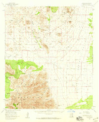
1958 Map of Gleeson
USGS Topo · Published 1959About this map
The settlement of Gleeson anchors the northern reaches of this mid-century survey, surrounded by the high-desert landscapes of the Dragoon Mts and Sugarloaf Hill. This is a landscape defined by the search for water and mineral wealth, marked by numerous Shafts and a local Cem near the town site. The rugged geography of the Mule Mountains gives way to the open Sulphur Springs Valley, where an Old Railroad Grade and several irrigation pipelines trace the efforts to connect this remote territory. Scattered cattle operations like Reeves Ranch, Harmon Ranch, and the Dixie Canyon Ranch rely on a network of named water sources, including Antelope Spring and Thompson Tank. The presence of Gold Camp and various prospect pits indicates the lingering mining activity that once drove the region's economy.
Find a feature on this map
79 named features on this map. Tap any name to fly to it.
Don’t see what you’re looking for? This feature index may not catch every label — zoom into the map to look around manually.
Map Details
Editions of this 1958 Gleeson Map
3 editions found
Other maps of this area

1902 · Bisbee
USGS Topo · 1:62,500

1910 · Bisbee
USGS Topo · 1:62,500

1914 · Hereford
USGS Topo · 1:125,000

1914 · Douglas
USGS Topo · 1:62,500

1915 · Benson
USGS Topo · 1:125,000

1916 · Pearce
USGS Topo · 1:125,000

1916 · Douglas
USGS Topo · 1:125,000

1919 · Douglas
USGS Topo · 1:125,000

1922 · Swisshelm
USGS Topo · 1:62,500

1922 · St. David
USGS Topo · 1:62,500