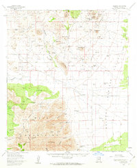
1958 Map of Gleeson
USGS Topo · Published 1963About this map
The high desert landscape of Cochise County is defined here by the convergence of the Dragon Mountains and the northern Mule Mountains. In the late 1950s, the settlement of Gleeson remained a central point of interest, complete with a local Cemetery and proximity to mining remnants at Gold Camp. The map documents a transition from early industrial efforts to a ranching economy, evidenced by the numerous family-named properties like Reeves Ranch, Harmon Ranch, and the H O Davis Ranch.
Find a feature on this map
76 named features on this map. Tap any name to fly to it.
Don’t see what you’re looking for? This feature index may not catch every label — zoom into the map to look around manually.
Map Details
Editions of this 1958 Gleeson Map
3 editions found
Other maps of this area

1902 · Bisbee
USGS Topo · 1:62,500

1910 · Bisbee
USGS Topo · 1:62,500

1914 · Hereford
USGS Topo · 1:125,000

1914 · Douglas
USGS Topo · 1:62,500

1915 · Benson
USGS Topo · 1:125,000

1916 · Pearce
USGS Topo · 1:125,000

1916 · Douglas
USGS Topo · 1:125,000

1919 · Douglas
USGS Topo · 1:125,000

1922 · Swisshelm
USGS Topo · 1:62,500

1922 · St. David
USGS Topo · 1:62,500