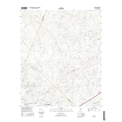
2017 Map of Elgin
USGS Topo · Published 2017About this map
The town of Elgin serves as a focal point in this 2017 survey, situated near the boundary where Richland and Kershaw counties meet. This area of South Carolina displays a dense network of water features and small impoundments, including White Pond, Little White Pond, and the larger Tucker Lake near Pontiac. The terrain is defined by the winding paths of Twentyfive Mile Creek and its various tributaries like Bear Creek and Flat Branch, which historically shaped the development of local agriculture and milling. Evidence of this early industry persists in labels such as Lotts Mill Pond. Modern infrastructure, including the northern reaches of Columbia, contrasts with these natural features and named rural corridors like Smyrna Church Road, illustrating the ongoing expansion of the region toward Lugoff.
Find a feature on this map
210 named features on this map. Tap any name to fly to it.
Don’t see what you’re looking for? This feature index may not catch every label — zoom into the map to look around manually.
Map Details
Editions of this 2017 Elgin Map
This is the sole edition of this map. No revisions or reprints were ever made.
Other maps of this area

1935 · Camden
USGS Topo · 1:48,000

1935 · Killian
USGS Topo · 1:48,000

1937 · Killian
USGS Topo · 1:62,500

1938 · Camden
USGS Topo · 1:62,500

1938 · Hagood
USGS Topo · 1:62,500

1941 · Spartanburg
USGS Topo · 1:250,000

1942 · Camden
USGS Topo · 1:125,000

1953 · Messers Pond
USGS Topo · 1:24,000

1953 · Blythewood
USGS Topo · 1:24,000
1953 · Fort Jackson North
USGS Topo · 1:24,000