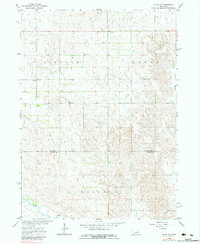
1963 Map of Elgin NW
USGS Topo · Published 1983About this map
Oakland, Logan, and Lincoln townships meet in this rural portion of Nebraska's Sandhills edge, as documented during the early 1960s. The landscape is defined by the winding course of Beaver Creek in the south and Blacksnake Creek in the northeast, providing essential drainage for this agricultural region. Evidence of organized rural life is visible in the placement of the Townhall and School No 91, which served as central hubs for the surrounding farmsteads. The map also delineates the jurisdictional boundary between Antelope and Boone Counties, illustrating the administrative layout of the Missouri River Basin during a period of steady land use. Topographic details reveal the subtle variations in elevation that dictate the path of local roads and the distribution of seasonal water channels.
Find a feature on this map
8 named features on this map. Tap any name to fly to it.
Don’t see what you’re looking for? This feature index may not catch every label — zoom into the map to look around manually.
Map Details
Editions of this 1963 Elgin NW Map
3 editions found

Other maps of this area

1955 · Broken Bow
USGS Topo · 1:250,000

1955 · O'Neill
USGS Topo · 1:250,000

1956 · Broken Bow
USGS Topo · 1:250,000

1959 · O'Neill
USGS Topo · 1:250,000

1960 · Spalding 2 NE
USGS Topo · 1:24,000

1960 · Spalding 2 SE
USGS Topo · 1:24,000

1963 · Petersburg
USGS Topo · 1:24,000

1963 · Neligh SE
USGS Topo · 1:24,000

1963 · Deloit
USGS Topo · 1:24,000

1963 · Neligh SW
USGS Topo · 1:24,000