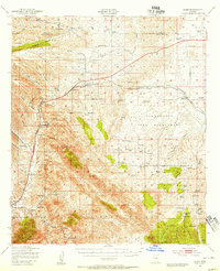
1947 Map of Elgin
USGS Topo · Published 1955About this map
The historical military presence and ranching culture of Southern Arizona are clearly visible in this mid-century survey of the Sonoita and Elgin area. Highlighting the region's 19th-century frontier history, the map identifies the Old Fort Buchanan Ruins and the nearby Old Fort Crittenden Ruins, located west of the Southern Pacific railroad line. The landscape is defined by an extensive network of named homesteads, such as the Hacienda Los Encinos, Star King Ranch, and Crown C Ranch, many of which are situated along the drainages of Sonoita Creek and the Babocomari River. Within the Coronado National Forest, the terrain rises toward Mt Hughes and Red Mountain, while local social centers like the Sonoita Sch and County Fairgrounds mark the community's development. Resource extraction is noted at the Durham Mine, tucked into the hills south of the San Ignacio Del Babocomari land grant.
Find a feature on this map
89 named features on this map. Tap any name to fly to it.
Don’t see what you’re looking for? This feature index may not catch every label — zoom into the map to look around manually.
Map Details
Editions of this 1947 Elgin Map
2 editions found

Other maps of this area

1904 · Patagonia
USGS Topo · 1:125,000

1905 · Patagonia
USGS Topo · 1:125,000

1905 · Nogales
USGS Topo · 1:125,000

1914 · Hereford
USGS Topo · 1:125,000

1915 · Benson
USGS Topo · 1:125,000

1922 · Agus Caliente
USGS Topo · 1:62,500

1922 · Sunnyside
USGS Topo · 1:62,500

1926 · Whetstone
USGS Topo · 1:62,500

1926 · Helvetia
USGS Topo · 1:62,500

1932 · Lochiel
USGS Topo · 1:62,500