
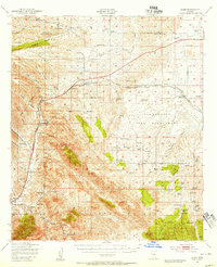
1947 Map of Elgin
USGS Topo · Published 1953About this map
The San Ignacio Del Babocomari land grant dominates the eastern portion of this Arizona landscape, where the Southern Pacific railroad line connects the small ranching hubs of Elgin and Sonoita. This 1947 survey captures a ranching-heavy economy just after the war, dotted with family names such as Wilson Ranch, Putnam Ranch, and Hacienda Los Encinos. Of significant interest to local historians are the military and pioneer remnants found here, including the Old Fort Buchanan Ruins and Old Fort Crittenden Ruins near Sonoita Creek. The terrain transitions from the high peaks of Mt Hughes and the Canelo Hills into the drainage of the Babocomari River, while the presence of the County Fairgrounds and Sonoita Sch indicates the area's role as a regional community center for the surrounding Coronado National Forest.
Find a feature on this map
90 named features on this map. Tap any name to fly to it.
Don’t see what you’re looking for? This feature index may not catch every label — zoom into the map to look around manually.
Map Details
Editions of this 1947 Elgin Map
2 editions found
Other maps of this area

1904 · Patagonia
USGS Topo · 1:125,000

1905 · Patagonia
USGS Topo · 1:125,000

1905 · Nogales
USGS Topo · 1:125,000

1914 · Hereford
USGS Topo · 1:125,000

1915 · Benson
USGS Topo · 1:125,000

1922 · Agus Caliente
USGS Topo · 1:62,500

1922 · Sunnyside
USGS Topo · 1:62,500

1926 · Whetstone
USGS Topo · 1:62,500

1926 · Helvetia
USGS Topo · 1:62,500

1932 · Lochiel
USGS Topo · 1:62,500